Friends my own age have told me of challenging hikes they've done recently. I'm almost totally disabled by arthritis so to compensate for my current immobility I thought it might be amusing to record some of the walks and hikes I did in the past.
My hardest walks (e.g., Tour of Mt Blanc) were taken in my twenties and thirties, but since I don't have digital images from that century, I'll start with a walk I did on my 53rd birthday and continue to my final outing, which was in my 71st year. Over that time there's a decline in ambition as, first, cervical stenosis, then atrial fibrillation, then arthritis took their toll, with some temporary restitution thanks to surgery.
Incidentally, as someone who uses a walking cane, I find the reaction of other people to be interesting, especially on public transport. In London (where I grew up), apparently fit and healthy young people will push me aside in order to get to the disabled seats ahead of me. In Japan, people in those seats will instantly give them up if an elderly Japanese comes along, but will ignore me unless I say something. In Rio de Janeiro and Moscow, half the subway car will leap to its feet to offer me a seat the moment I enter. There seems to be a law favoring the elderly in Rio and I was often escorted to the head of any line I happened to be in. A similar thing happens at airport security in many countries.
Let me note that I've done many more travels than these--here, I've just selected a subset where the walks were of interest (and I may add few more). Over the years I've visited all 50 US states (in fact, all 50 state capitals), all 21 California Missions, 46 of the 47 Japanese prefectures (my plan to visit the 47th for my 70th birthday was thwarted by Typhoon Hagibis), the Arctic and Antarctic (by cruise ships), and more than 100 countries. I've also flown at Mach 2 on Concorde, seen the Aurora Borealis, two total eclipses of the sun, and one of the moon, so I'm not too frustrated by my present homebound status. BTW. I have a page of hints on travel to such sights.
Click on thumbnails for larger versions, and then on those for the actual photos (which are still not full resolution). The EXIF data gives the Pacific Standard Time and date. Some sections have a link to additional photos.
Following back surgery in the 1990s, I used to take a brisk 3 mile walk every morning. I was religious about it and never missed a day, even in pouring rain. As a result, I was quite fit at this time.
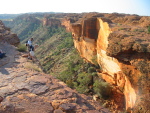
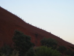
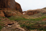
Of course, I also went to Uluru, Kata Tjuta (The Olgas), and the MacDonnell range and did some modest walks there. Above right is a picture of people climbing Uluru (which I believe is no longer allowed).
I'd intended to keep this log to just two photos for each walk, but I also visited some other geological wonders in Australia and thought it worth including some shots of them (below).
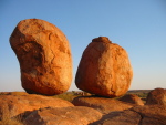
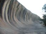
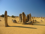
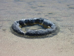
First are the Devil's Marbles (about 300 miles north of Alice Springs), then Wave Rock (about 100 miles East of Perth in Western Australia), and The Pinnacles (about 100 miles North of Perth). Finally, Lake Thetis is near the Pinnacles and has stromatolites; these are descendants of the oldest living things on Earth (about 3.5 billion years) and are responsible for creating the oxygen in our atmosphere.
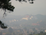
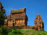
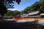
Chengde (not to be confused with Chengdu, where the pandas live) is a city about 150 miles northeast of Beijing. It's at an altitude of about 1,000 feet and in summer it is considerably cooler than Beijing. Consequently, in the 1700s, the emperors built a mountain resort there as their summer residence. It has a massive garden/park, about 6 miles around, with various pagodas and palaces, and eight temples located some distance outside. The temples are built in varying styles based on architecture from Tibet and China, reportedly so that forced "visitors" would feel at home. They are more like stage sets than real temples (notice the "blind" windows). There is a massive rock pinnacle a few miles further out, called "hammer rock" in English, though I'm told the local name is more phallic.
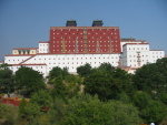
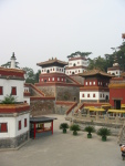
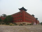
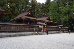
I stayed in Chengde for a few days in 2004 and explored the mountain resort (first picture above) and the outlying temples (only six were open to the public). These include Putuo Zongcheng (second picture) which is modeled after the Potala Palace in Lhasa, Puning (third picture) which is modeled after the Samye Monastery in Tibet, and Xumi Fushou (fourth picture), which is also Tibetan.
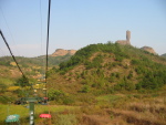
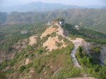
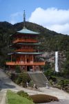
The temples are massive and mostly built on hillsides, so just exploring them is a pretty good workout. But for my walk I'll focus on Hammer Rock. The first picture above is a distant view of Xumi Fushou temple (taken from Putuo Zongcheng) and you can just see Hammer Rock in the background above and right of the pagoda, almost lost in the pollution haze. I took a ropeway (like a ski lift) part way up (second picture) and hiked the rest of the way to the base of the monolith (third picture is looking down at the path up). It's pretty steep, but paved. I took some photos of the temples from there but the pollution was so bad you cannot see much, so the final picture (of Putuo Zongcheng with Xumi Fushou below and to the right) is from lower down.
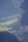
Next day, I walked the Magome to Tsumago stretch of the Nakasendo: the "middle way" that was one of the routes from Kyoto to Edo (Tokyo) during the samurai era. It's a hard slog uphill in the summer heat and humidity from Magome, mostly on roads, to the summit, then downhill on trails to Tsumago--but in the photo (on the right) you'll notice there's a road not far from the trail. Overall, not a worthwhile outing, in my opinion, despite its fame and popularity.
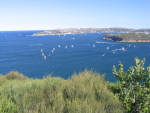
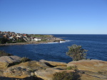
Coogee to Bondi (photo on right) is only a mile or so and is a pleasant pre-dinner stroll.
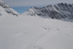
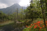
Another day, I took the railway that tunnels through the Eiger and comes out at Jungfraujoch, the saddle below the Jungfrau. There's a snowplowed trail from there over the Aletsch Glacier to the mountain hut below the Monch. You can see the trail in the view above right from the observation tower at the train station. It's a gentle ascent and about 2.5 miles there and back, but it is in soft snow at 11,975 feet (the hut is the highest in Switzerland). I had a nice lunch at the hut and returned.
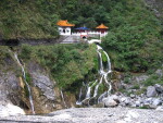
In Hue, I explored the tombs along the Perfume River and the massive, ruined citadel. It rains all the time in Hue, so my extended walk around the citadel was a pretty damp affair. I have a separate web page of doorways in the Citadel here.
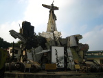
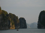
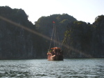
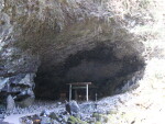
There's also a citadel in Hanoi with a war museum nearby that includes a remarkable semi-sculpture of wrecked planes (first picture below). And, of course, while in Hanoi I took an overnight boat trip to the spectacular karst scenery of Halong Bay (actually Bai Tu Long Bay, which is less crowded, second and third pictures). The boat stops at a couple of islands where you can hike up to caves or viewpoints, but these were beyond me.
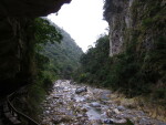
In Taroko Gorge, I took a couple of guided walks, including the Sha Ka Dang and Swallows Grotto Trails show above. These were pretty good, mostly level, alongside the river--though access to Sha Ka Dong Trail did involve descending about dozen flights of spiral steps wrapped around a bridge leg.
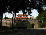
Continuing my circumnavigation, there's a lot of interesting things to see in Tainan, including the old Dutch area of Anping (below).
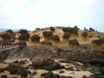
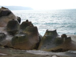
Taipei is also interesting. One day, I took a public bus up to Yehliu, where there is a trail among fascinating rock formations along the seafront (photos below).
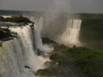
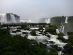
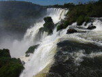
The Iguazu Falls are among the most magnificent natural sights I've seen. One day I walked along the Brazilian side (left photo), where you can also descend to walkways into the river so you are facing the falls (middle photo). I then spent a couple of nights on the Argentine side, where the highlight is to walk out along a walkway at the very rim (with the wreckage of previous versions beside you) to the "Devil's Throat" (right photo).
I took an enjoyable cruise from Florida, through the Panama Canal, and around the north west corner of South America to Valparaiso, Chile.
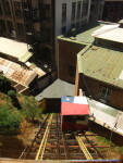
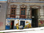
Valparaiso is a very interesting place, built on astonishingly steep hills with ascensors (funiculars) for access (photo on left above), and high-quality graffiti. I stayed there for a few days and one morning joined a walking tour with "tours4tips". This was excellent, though I found the steep terrain very difficult to navigate (right photo).
I spent Christmas and several days after in Santiago, Chile, which is pleasant and interesting, with a West Coast vibe and climate.
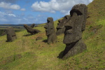
I've taken other cruises that started or ended in Valparaiso. Among side-trips from there, I've been to Easter Island (below left), and the Andes (below right, not much snow in summer).
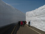
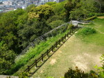
The Tateyama-Kurobe Alpine route is a high-altitude traverse of the Japan Alps that uses a variety of transport modes: train, funicular, bus. To open the bus section in Spring, they snowplow down about 25 feet to reach the road, giving rise to the "Snow Canyon" shown in the photo on the left below. You can walk along it.
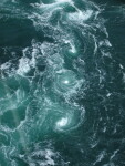
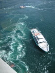
Another scenic wonder is (collectively) the Naruto Whirlpools off Shikoku (the small island bottom center of Japan). The "Uzu-no-michi Promenade" is a walkway suspended underneath the Onaruto Bridge (a road bridge on one of the routes to Honshu, the main island), which is from where I observed the second and third photos. The whirlpools are up to 50 feet across; the third photo shows a sightseeing boat for scale. It looks as if the boat has caused the whirlpools, but that's not so. The whirlpools are dependent on the tides, and therefore the phases of the moon, so you need to time things carefully.
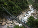
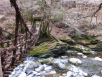
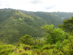
Further to the South and East of Shokoku is the very remote Iya valley, where there are a number of vine bridges (left picture below). My walking was limited to getting from parking spots down to the river.
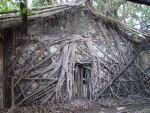
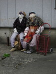
Just outside the Iya valley is the village of Nagoro, which is notable for its "scarecrows" (middle picture). Like much of rural Japan, the village has become depopulated as young people move to the cities. One lady moved back to care for her mother and missed the people that used to be there. So she made "scarecrow" puppets of her absent friends and neighbors and populated the village with them. There are now more than a hundred and they outnumber the living inhabitants.
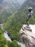
There are some very steep river canyons in this area and one of them has its own version of Mannekin Pis (rightmost photo). Japanese dudes would stand beside him and duplicate his feat. Unfortunately, a few of them went over the edge and died on the rocks some hundreds of feet below, so now it is fenced off.
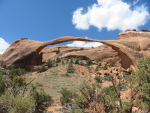
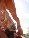
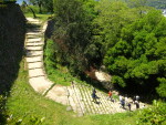
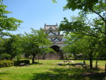
There are 12 original castles in Japan and I've been to all of them; surprisingly for such a small island, four of them are on Shikoku. Uwajima castle is very remote, in the southwest corner of the island. The ascent to the tenshu (keep) is up the uneven steps shown in the photo on the left below. I didn't think I could handle that so I asked a gardener if there was another way (I speak enough Japanese for these kinds of interactions). He led me through several layers of "keep out", "danger" and "construction" tapes and pointed to rickety-looking scaffolding with a spiral stair inside going up 6 stories. I felt too far in to back out, so crept upwards. It was actually fairly solid. You can see the top in the second photo (not the rails going diagonally down, that's how the construction people haul their stuff, but the thing behind it at the top).
It was worth it: the third photo is the actual castle. I descended the regular way.
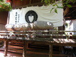
If you've come all the way to Uwajima, you might as well see the other sights in the neighborhood, and that would include the Taga fertility shrine shown in the fourth photo.
One was in Nuku Hiva in the Marquesas. Herman Melville was here, but not Gauguin--he lived on the neighboring island of Hiva Oa. In the morning, I took a very good van tour, up over the central mountains to the remote far side of the island (first picture above). Then, after lunch, I pottered along the seafront to the cathedral (second and third pictures). It was fiercely hot and humid and I had to stop to rest several times, but I made it. The walk along the seafront was very scenic, with parks and memorials (fourth picture).
Another walk was in Rangiroa. This is one of the largest atolls in the world, about 25 miles across. Atolls are the remnants of a sunken sea mount (it was Darwin who worked this out). Volcanic activity creates a mountain on the ocean floor and eventually this grows big enough to break the surface (you can see this happening right now near Tonga). Eventually it stabilizes and you have a rugged mountain rising steeply out of the sea (the Marquesas are like this). Corals grow in the surrounding water. Over millions of years, the weight of the sea mount causes it to gradually sink back into the ocean floor and as it does so, the corals grow higher and higher to stay near the surface. There are breaks in the coral where fresh water rivers from the central mountain empty into the sea. As the mountain subsides, the area of the protruding peak becomes smaller and smaller and so a lagoon forms in the area between the shrinking land and the coral. The islands around Tahiti (the Society Islands) are like this. Eventually, the central peak subsides completely and you have an atoll. The Tuamotu Islands, of which Rangiroa is one, are like this. There is one further possibility: tectonic movement can thrust an atoll upward, so you have a cylinder of coral with a central hole that gradually fills with stuff. Christmas Island (Kiritimati) in Kiribati is like this. (I've been there but don't have a decent photo; this link provides a good one.)
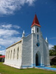
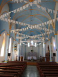
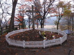
There are only two passes into the Rangiroa lagoon. The ship squeezes though the Tiputa Pass (first picture above) and parks in the lagoon and runs its tenders to one side of the pass. The village of Tiputa is on the other side. Most tourists do snorkeling and other water activities but I took a water taxi across the pass (second picture) and walked to the village of Tiputa. It has a delightful church (Our Lady of Peace, third and fourth pictures) but is otherwise residential, with a couple of small shops.
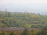
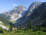
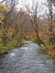
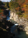
Japan is a mountanous country and consequently it has lots of steep river valleys, some of which have carved attractive canyons. Some you can walk along, others require a boat.
A few miles upstream, the river goes through a sheer-sided canyon (photo on the right) that has boat trips in summer.
The Oirase Stream, which is quite far north, is a famous viewing site for Autumn leaves (photo below left). It's more of a bus tour area than hiking. I had a rental car and there was already snow on the ground coming over the mountains from Aomori at the end of October.
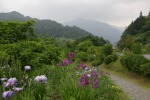
Further south is the well-preserved Samurai town of Kakunodate (middle photo). A place to stroll rather than hike. Not so far away is the Dakigaeri Gorge (photo on the right). The full trail is about 6 miles, but I just did the first half mile or so (up to a suspension bridge)
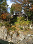
A dango is a Japanese sweet: a ball of rice dumpling covered in sticky goop and served impaled on a stick (usually four at a time). Along the Genbikei gorge there is a cafe perched high on the canyon wall that has a ropeway down to a resting spot beside the river on the opposite bank. You write your order on a slip of paper and ring a bell. A basket comes down the ropeway from the cafe (photo on the right) and you depost your order and money and they haul it up and a few minutes later, down comes your treat.
When I get there and go to buy my ticket, I ask again, and again am told they can do that. So I sit in the waiting room with other people for a few minutes until a boat returns from its trip and takes us on board. But there are no seats: it's shoes off and sit on a tatami. I complain to the lady collecting tickets and she says no problem and disappears. She returns with a chair from the waiting room and plants it down on the front of the boat and invites me to sit. As an extra concession, I'm allowed to keep my shoes on. So off we go with all the Japanese people sitting on the floor and me up front like the figurehead on a sailing ship.
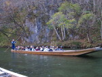
The Japansese people had brought food for the ducks and fish and passed some up to me so I guess they didn't feel put out by my special treatment. The boat goes upstream for a way, and parks at a small beach where we get out and look around, then returns. It is quite scenic (photo on the right). The boatman tells stories and sings on the way back, where the river does the work.
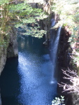
From ignorance, I failed to go to the Akechidaira Observatory, which gives a spectacular overview of the Kegon Waterfall in combination with Lake Chuzenji.
The road past the waterfall and lake continues 200 miles or so to Ueda in Nagano and is designated "The Romantic Road" in a tribute to the one in Germany.
I travelled about 30 miles along it in order to visit Fukiware Falls. These are very interesting as they form a pair of waterfalls that face each other. It is hard to get a good photo (below) but the idea is that the river flows over a shelf of rock that ends with a Vee cutout and the water flows over both sides of the Vee. It's a short walk along the riverbank to get there.
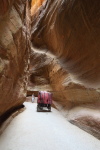
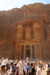
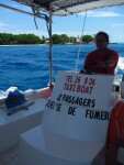
But for my walk, I'll feature a trip from the cruise port of Aqaba to Petra. You take a bus across the desert to the entrance to Petra, then walk down The Siq (picture on the left above), which is a descending narrow path between rock walls, about a mile or so long. Then you emerge in front of the amazing Treasury (picture on right), along with a few thousand friends from the cruise ship and another one that was also in port (plus it was a public holiday in Jordan).
The walk down The Siq and back was at my limit. If I were to do this again, I'd take a horse cart down to the treasury and back and save my walking strength for the structures further along, although the Monastery would still be beyond my capabilities. And I'd choose a less crowded day!
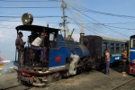
The traditional way to get to Darjeeling is by the narrow gauge "toy train" that winds up from the lowlands. However, this takes seven hours and was cut by a landslide when I was there, requiring a bus to workaround the gap. So I flew to Bagdogra and took a car from there. I did later do an excursion on the toy train, however, from Darjeeling to Ghum and back (first picture below). The locomotive is more than 100 years old and needed several repairs during our trip.
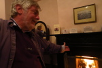
I stayed at the Windamere Hotel, which was built for English bachelor tea-planters more than 100 years ago and retains much of that ambiance: a man builds a coal fire in your room each afternoon, and in January you need it (second picture).
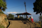
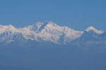
My goal was to see Kanchenjunga, which is the third highest mountain in the world. As with all viewpoints in India, the designated spot has a shack with folks selling tea and food etc. (third picture). The viewpoint is not far from the hotel but access is down a steep track that I found pretty unnerving, so I count it as a hike. Pollution and dust in the atmosphere from construction in Sikkim hid the view most days, but one morning I got lucky (fourth picture).
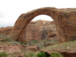
The access path was not bad (left picture), but I resisted the urge to do the final quarter-mile to stand right under the bridge (right picture).
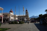
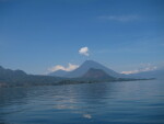
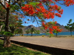
I'd been to most of the ports before, so didn't get off the ship at many of them, but Nicaragua and Guatemala are more interesting than most. I'd previously been to Granada in Nicaragua (left and center pictures above) and Lake Atitlan in Guatemala. Aldous Huxley thought Atitlan was the finest lake in the world, but he was nearly blind; it is a splendid sight, though (picture above right).
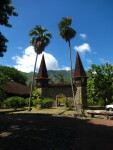
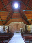
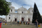
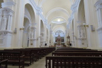
This time, on New Years Eve, I took a bus trip from the port in Corinto, Nicaragua, to Leon. Most people then took a walking tour of the town, but I was only able to hobble to the cathedral and back. It's the largest in Central America (left picture below) and has a fine, austere interior (second picture).
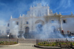
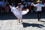
On New Year's Day, I did a similar trip from the port of Puerto Quetzal, Guatemala, to the ancient city of Antigua. As I was leaving the cathedral (concentrating on descending unprotected steps and crossing the unevenly cobbled and strangely empty street in front), people were yelling and waving at me. I don't speak a word of Spanish so carried on--and then saw the reason for their concern. They had lit a firework display, which involved a strip of firecrackers along the street I had just crossed (third picture).
And that was my last walk--out with a bang!
Created with igal-wt plus some hacks by me